Monday, May 14, 2012

Wrightsville NC to the Chesapeake - April 2012

A cold front came through on the way to Wrightsville Beach, so I arrived with a little bit of wind to approach the dock at the marina. And, the weekend was a little cool for the beach, but still nice.  Kim and Katherine arrived Thursday afternoon after I had made a trip to the West Marine.  We had a nice visit for the weekend.  We went to see the Hunger Games at a theater in Wilmington, had a nice day walking on the beach, and went to Easter Service on Sunday.  Katherine headed back to Raleigh on Sunday afternoon; Kim and I headed north on the ICW for a planned seven day trip back to White Stone, Va.


Kim and Katherine on Wrightsville Beach

A half day of travel got us to Camp Lejeune for the nights anchorage.  Then another day got us past Oriental NC.  We stopped in Broad Creek - a nice anchorage, once you figure out the entrance.  This is also home to the River Dunes marina and housing development.  Worth a visit on the next trip.  From here, we continued across the Pamlico River, past Belhaven and through the Pungo-Alligator Canal.  We anchored just past the exit of the canal at the base of the Alligator River.  The next morning brought an anticipated cold front - but stronger than expected.  We started up the river, but encountered stronger winds than expected.  30 plus knots directly on the nose made for slow, cold travel.  We decided to turn back to the anchorage and wait for the winds to lay down.  In the early afternoon, we followed other boats up the river, and through the Alligator bridge.  The crossing of the Albemarle Sound started out OK, but turned nasty as we went along.

Bird Gathering - Crossing the Albemarle Sound
Winds were projected to settle down below 20 knots - and they did for a bit.  But later in the afternoon, they picked back up to the mid - 30's.  We discovered why they talk about this shallow sound getting rough in a high wind.  It was like traveling through a washing machine - a confusing wallow of seas that came from the front, or from either side, with no particular pattern.  This lasted for the whole crossing.  This was absolutely the coldest week of the entire trip. Adding to the fun, the chart plotter decided to go haywire today.  While it was working, it was reading in reverse - the boat icon was facing stern first, and the course was heading down the screen rather than up.  This added an interesting navigational challenge. We made it across the Albemarle and anchored in another Broad Creek, just on the northern side.


Broad Creek - North of the Albemarle

From here, we stopped at Coinjock for fuel, and made it to Great Bridge that afternoon.  We spent the night at the Atlantic Yacht Basin, and passed through the lock the next morning.

Kim - in the lock - Great Bridge, Va
After the lock, the morning was spend navigating the bridges through Norfolk, and following the river out into the Bay.  We were treated to a rare sight leaving Norfolk - a returning submarine with a Coast Guard escort.  When we got into the Chesapeake that afternoon, it was a pleasant motor sail north.  We arrived back on Indian Creek that evening and entered the slip at 8:00 - just as the last light was fading.  Back home on April 14 - about a 5 month trip.  Now for the next one....

Back home - Pitmans Cove off of Indian Creek


Charleston SC and North - March 2012

After Mom's funeral, Kim dropped me back off in Hilton Head, and met me the following weekend in Charleston.  It was a two day trip, and was uneventful, so I got there early and got settled into the City Marina for the weekend.  North of Beaufort, I was treated to fly overs of Navy jets doing touch and go landings. Not sure the picture does it justice, but here is one shot I got of a passing jet.

Boats and Planes - north of Beaufort

Charleston is one of my favorite cities - it's just a lot of fun to walk around in, and has some great restaurants. We were in town for the annual Cooper River Bridge Run - a 10K run and walk.  Kim and I were walking it, while our daughter and her boyfriend, and several others were running the race. My sister, Pam joined us for the weekend.
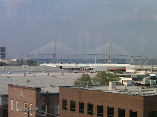


Cooper River Bridge - from downtown Charleston

Top of the Bridge - halfway point

It was a great weekend. We got together for a good seafood dinner at Shem Creek, did the race (we all survived), and then just chilled out after the race. The race had record attendance - 14,000 souls.  It kind of overwhelmed the race organization, so the start was delayed (Kim and I left the start for coffee and donuts - and still got back before our corral got going) and provisions ran out (water stations with no water) - but overall, still a good event

After everyone headed home, I left the following morning heading up the ICW to Wrightsville Beach.  It was a four day trip, with more than it's share of adventure.  The first day after leaving Charleston got me to an anchorage just south of Georgetown.  It was in Winyah Bay, just after coming through the land cut. I lived to regret this one.  The anchorage was not sheltered, but winds were not in the forecast. It took a couple of tries to set the plow anchor (or what I thought was set).  Shortly before dark, the winds picked up, and the boat began dragging.  It became a routine of lifting the anchor, motoring up and resetting.  The problem was the wind was strong enough that I couldn't get slack in the rode long enough to completely raise the anchor (since I was single handing).  Finally, it looked like I was holding, but just for good measure I threw in a second anchor (brand new Fortress) and retired for the night.  Early the next morning, I awoke to a loud pop and went on deck to see that I had drug a good way across the waterway.  The pop was the anchor rode for the Fortress - it looked like it shredded on a sharp object and separated - goodbye anchor.  When I raised the main anchor to get underway, I saw the  source of my original anchoring problems.  The plow had a cinder block hanging from each side, with a nylon line holding them together.  The only way to free it was to hang off the bow with a knife to cut the nylon line - fun.  After I freed the anchor, I was underway again - a little wiser about anchorage selection.

The morning trip was a nice motor up the Waccamaw River.  The river water is the color of dark tea, but the river is wide and deep, and very scenic - with Cypress trees lining the bank. From there, it was into the landcut passing Myrtle Beach.  Anchorage for the evening was a nice little river just south of the NC line at Little River SC.      

Waccamaw River - north of Georgetown
The next day had me passing through Southport NC and up the Cape Fear river to Carolina Beach for the night.  Southport marked the completion of a large circle, since this is where we originally headed offshore on the trip down.  This leg also had the next bit of adventure.  Just after passing through Snow's Cut into Carolina Beach, I passed a barge heading into the cut.  Snow's cut is very narrow with a strong current - so it a challenge to navigate normally.  As I headed into Carolina beach to find an anchorage, I listened on Channel 16 to the barge captain.  He was heading into the cut with the current and encountered a small fishing boat (that apparently wasn't visible to him).  Following directions from other boats in the cut (who were trying to stay out of the way), the barge was trying to back down against the current to avoid swamping the small boat.  It was a bit of high drama for about 5 minutes - and I'm sure it was stressful for the other boats in the cut. But - everyone came thru OK.

I headed into Wrightsville Beach the next morning....


Hilton Head Island, SC - March 2012

It was another two days on to Hilton Head.  Since the goal was to meet family in Charleston for the Cooper River Bridge Run, I had extra time on my hands.  The plan was to spend a week hanging out in Hilton Head and doing projects on the boat.  Unfortunately, I got the news that my mother had passed away.  She was a lovely, gentle lady, and at 92, had a good full life.  I ended up leaving the boat in Hilton Head to return home for the funeral.

The second day out from St Simons, I awoke to a chart plotter that did not want to work.  So, this was a day of reverting back to paper charts and visual navigation.  Guess we all need to do this once in a while to keep up the skills.  That evening, before I got into Hilton Head, I was anchored just to the south in the bend of a river at the southern end of Daufuskie Island. A line of thunderstorms came through, with pretty dramatic lightning - a hard thing to capture in a picture,but I got at least one shot.  


Thunderhead - Daufuskie Island SC

When I got to Hilton Head the next day, I went to the top of Broad Creek and anchored off of Shelter Cove.  This gave me a couple of days to visit the island, trouble shoot the chart plotter and water heater (no hot water) and have dinner with friends, before heading back to Charlotte. The anchorage off of Shelter Cove was a good one - 10 feet of water, and no one else around.

Shelter Cove - at Hilton Head Island

The afternoon was spent touring the island on a rented bicycle (and visiting West Marine). Later, I met friends from Charlotte at their place in Palmetto Dunes.  We went for a little light refreshment and seaside entertainment - which turned out to be a very nice combo.  They played a good mix of classic and contemporary music - and one of the guys could really hit the high notes.

Entertainment - Palmetto Dunes - Hilton Head SC

The chart plotter turned out to be a blown fuse.  The water heater was a kinked hose.  Pretty quick repairs. After a last night at anchorage, I left the boat at Palmetto Bay marina, went back to Palmetto Dunes for dinner (nice friends), and left the next day for Charlotte (driven by the same friends - now you can't beat that).  Here's a shot of the last night at anchorage....

Sunset - Shelter Cove


St Simon's Island, Ga - March 2012


Well, it took about a month for the repair work on Dreamer to be completed in St Augustine.  A lot of fiberglass work to the rudder, and the aft section of the hull.  The good news is that it should be a lot stronger than it came from the factory.  I left Charlotte in early March for St Augustine.  It turned out that the best way to get there was by Greyhound bus - haven't traveled that way in quite a while. St Augustine is a beautiful city - will have to stop again....

St Augustine Municipal Building

I left St Augustine for a leisurely trip up the ICW, with a few planned stops along the way. The first leg was to St Simons Island, Ga.  This was a two day trip.  I stopped by to check out St Mary's Ga on the way.  I had heard from several cruisers that this was a favorite place to leave their boats for extended storage.  It was a nice little town on the river, and a good possibility for long term storage. The two day trip was uneventful, except for picking up a crab pot at the entrance to St Mary's River. At least that's what I believe it was.  The helm was sluggish (like a weight hanging on the propeller shaft), and my first thought was that something had gone wrong with the recent repair.  Thankfully, by the time I stopped, had lunch and thought about it (climbing down to check things out and cut it free if necessary), it had worked itself free and the helm was back to normal. Thank goodness.  I spent one afternoon and night at St Simons - long enough to walk around the island.  This is one of the stops that it would have been good to have a bicycle on board.  But, it was a nice walk, and served to get me ready for the 10K walk soon to come in Charleston. 

From the pier at the end of the "town strip", I got a good picture of the St Simon's lighthouse,...

St Simons Lighthouse


And a very photo friendly pelican.....
St Simons Pelican